Ahlinya Visualisasi Data &
Pemetaan Wilayah
Dari Excel sederhana menjadi Peta Interaktif canggih. Kami membantu sales, manager, dan instansi mengambil keputusan berbasis lokasi dengan data yang aman.
Punya Data Excel?
Ubah data spreadsheet menjadi peta sebaran offline dalam hitungan detik. Tanpa internet, tanpa skill coding. Cocok untuk Sales & Manager.
Butuh Sistem Custom?
Jasa pembuatan WebGIS Enterprise (Dinas/Korporat). Fitur lengkap: Dashboard, Integrasi API, PostGIS, dan Manajemen User Kompleks.
Butuh Analisis Data?
Jasa olah data spasial tingkat lanjut: Analisis Hexagon, Clustering Wilayah, hingga Prediksi Lokasi Strategis dengan Python.
Kenapa Memilih Kami
Layanan Utama
🌍 Pengembangan WebGIS Kustom
Aplikasi mandiri atau enterprise yang disesuaikan dengan kebutuhan dan data Anda.
📦 Galerigis Pro Access
Berfungsi 100% tanpa internet — ideal untuk presentasi lapangan atau area tanpa koneksi.
🐍 Otomasi Data Spasial
Proses batch, analisis heksagon, dan pipeline data otomatis menggunakan Python.
🔥 Pengembangan Laravel Full-Stack
Aplikasi CRUD, REST API, dan integrasi sistem — stabil dan mudah dikelola.
Teknologi yang Kami Gunakan
Kami membangun solusi berbasis teknologi web modern dan open-source yang telah teruji.
Laravel
Pengembangan backend dan REST API yang andal.
Python
Otomasi data spasial dan analisis menggunakan library GIS modern.
PostgreSQL / PostGIS
Basis data spasial yang handal untuk analisis dan integrasi skala besar.
Leaflet
Peta interaktif ringan dan fleksibel untuk semua platform.
OpenLayers
Rendering peta web lanjutan dan kontrol tingkat tinggi.
GeoServer
Layanan OGC seperti WMS, WFS, dan tile caching untuk peta dinamis.
Proyek Unggulan
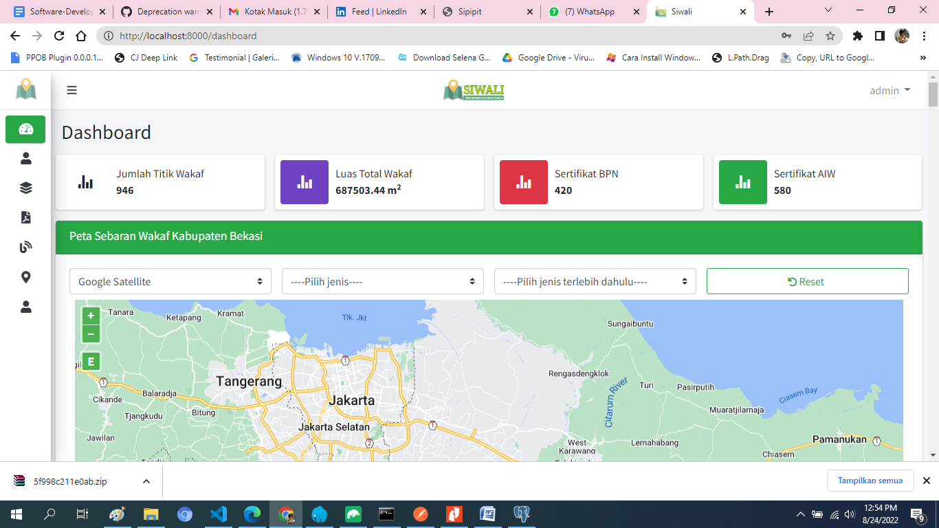
SIWALI WebGIS — Kementerian Agama
WebGIS berskala nasional yang menyediakan informasi spasial secara transparan dan interaktif.
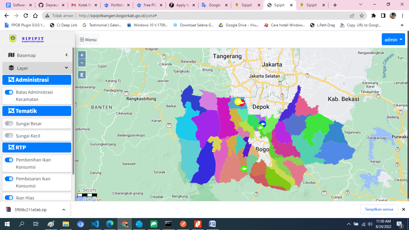
SIPIPIT — WebGIS Perikanan & Peternakan
Integrasi data sektor perikanan dan peternakan dalam satu platform geospasial.
Galerigis Pro Access
Toolkit profesional untuk presentasi peta secara offline — tanpa server.
Lihat Paket Harga →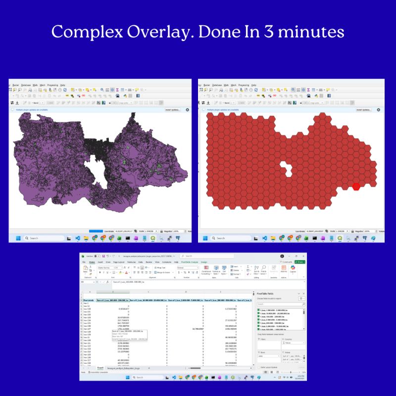
Jasa Analisis Spasial Hexagon
NEWLayanan olah data spasial otomatis. Output Peta SHP + Laporan Statistik Excel dalam hitungan menit.
Lihat Paket Harga →Tentang Kami
Kami adalah pengembang yang berfokus pada WebGIS dan solusi full-stack. Berpengalaman lebih dari 10 tahun di bidang GIS dan 4 tahun dalam pengembangan aplikasi web. Kami membantu Anda mengubah data menjadi peta interaktif yang mudah dipahami dan siap digunakan.